Future of GIS (updated Oct 2024)
Three Disruptive Changes Shaping Science
-
One-Dimensional AI Revolution: AI’s widespread integration into media, society, and science is reshaping how we process and generate information. While it excels at accelerating existing knowledge, it falls short in generating truly novel solutions. Think of it as a powerful tool for replication, not innovation.
-
Three-Dimensional Electromechanical-AI Revolution: The convergence of AI, electromechanical engineering, and advanced language models is poised to revolutionize manufacturing and transportation. Imagine hyper-intelligent machines capable of complex tasks, from assembling products to autonomously navigating vehicles.
-
Quantum Computing Revolution: The potential of quantum computing to break current encryption standards poses a significant threat to cybersecurity. However, the development of post-quantum cryptography, such as lattice-based schemes, offers promising solutions. These spatial constructions may have applications in areas like drone authentication, ensuring security in the face of quantum attacks.
While these technological advancements hold immense potential, their successful integration will require careful consideration of societal, psychological, and political factors. For instance, the transition to drone-based transportation will necessitate a shift in our collective mindset and infrastructure.
GIScience at the Forefront of Future Disruptive Science
GIScience stands poised to lead the way in several key areas:
-
Advanced Simulation and Modeling: GIScience should pioneer 3D simulations at various scales (micro, meso, macro) and leverage network science theories rooted in operations research to optimize spatial resources and minimize waste.
-
Data-Driven Analysis: Automated Bayesian analysis can provide unbiased posterior estimates from raw data, eliminating the pitfalls of relying on biased political unit data for social and behavioral research. GIScience can construct hierarchical Bayesian networks to uncover hidden patterns and biases within socioeconomic and built-form systems, forming a comprehensive geo-ecological network.
-
Realistic City Simulation: GIScience offers a unique platform for analyzing complex urban systems through realistic simulations with dynamic information layers. By integrating diverse data sources, we can gain valuable insights into urban dynamics and inform policy decisions.
-
Quantum Computing Applications: While ambitious, GIScience can explore the potential of quantum computing to address NP-hard problems, such as redistricting, with provable algorithms. Quantum entanglement could also revolutionize cartography, enabling the selective display of information based on user needs.
-
Cloud-Based Computing: The shift to cloud-based and high-performance computing can enhance GIScience capabilities, providing scalable resources and facilitating collaboration.
By embracing these advancements, GIScience can play a pivotal role in shaping the future of science and society.
Prioritizing Spatial Stochastic Operations Research in the Next Decade
Spatial Stochastic Operations Research (SSOR) offers a powerful framework for addressing complex spatial challenges. Key areas of focus should include:
- Transportation Simulation: Develop advanced simulations for autonomous vehicles and drones, incorporating stochastic optimization techniques to ensure safety and efficiency.
- Environmental Modeling: Utilize SSOR to create dynamic simulations of pollution profiles, climate models, and other environmental factors.
- Citizen Science Tools: Build user-friendly software for citizen science initiatives, including GIS-based tools for inventory management, redistricting, location-allocation, and climate change analysis.
- Quantum Computing Applications: Explore the potential of quantum computing to solve spatial NP-hard problems, such as optimizing autonomous delivery systems.
- Mathematical Tools: Leverage a combination of spatial-astronomy, spatial-econometrics, geography, and social science tools to enhance SSOR capabilities.
- AI Adoption: Prioritize the adoption of existing AI technologies, such as ChatGPT, rather than investing heavily in development. The rapid pace of AI advancement makes it more efficient to leverage state-of-the-art tools.
By focusing on these areas, we can harness the power of SSOR to address critical spatial challenges and drive innovation in various fields.
GIS/Data Science Curriculum in a Disruptive Era
In today’s rapidly evolving scientific landscape, a GIS/Data Science curriculum must prioritize operations research (OR) to address pressing challenges like climate change and optimize resource allocation. Spatial OR, in particular, offers valuable tools for optimizing spatial systems, from energy-efficient building design to sustainable transportation networks.
Spatial simulation, which incorporates stochastic OR, is essential for understanding complex spatial dynamics. For instance, GIS-based hospital traffic simulations can help mitigate the spread of infectious diseases like MRSA.
GIScience encompasses a wide range of spatial scales, from micro-level architectural design to macro-level global phenomena. By integrating GIS with OR and simulation techniques, we can develop innovative solutions to complex problems.
Stochastic optimization, a specialized area within OR, involves optimizing systems under uncertainty. It has applications in various domains, including autonomous vehicles and traffic management. GIScientists who master stochastic optimization can play a crucial role in shaping the future of transportation and other spatial systems.
WHITE PAPER on AI
WHITE PAPER on AI
Updated draft (5Oct 2023):
I’ve been dabbling with an AI problem called Superalignment …
Here’s is a take on the AI-Superalignment problem and my GIS-based ontological solution that involves automation/AI, risk, economic pricing and pricing as ‘oversight’ [clu.ai defines: Superalignment is the concept of ensuring that super artificial intelligence (AI) systems, which surpass human intelligence in all domains, act according to human values and goals.]:
 |
Superalignment is a concept in AI safety and governance that ensures super artificial intelligence systems, which surpass human intelligence in all domains, act according to human values and goals. It addresses the risks associated with developing and deploying highly advanced AI systems.
klu.ai
|
Superalignment: A 1-Dimensional to 3D Problem with Drones as a Testbed and Economic Pricing as a Solution
Abstract: This paper explores the concept of superalignment in the context of artificial intelligence (AI) and Geographic Information Systems (GISc). It argues that AI systems, particularly those controlling autonomous drones, pose a unique challenge due to the potential for real-world consequences arising from decisions made in a digital space. The paper proposes a novel approach to superalignment that leverages economic pricing mechanisms to incentivize safe and responsible drone operation.
Introduction:
The increasing sophistication of AI systems raises concerns about their alignment with human values. This is particularly true for AI applications that operate in the physical world, such as autonomous drones. These systems must be carefully designed and controlled to avoid causing harm.
This paper introduces the concept of superalignment, which refers to the challenge of ensuring that AI systems act in a way that is consistent with human goals and values across all dimensions, from the one-dimensional world of data and algorithms to the three-dimensional world of physical consequences.
Drones as a Testbed for Superalignment:
Drones provide a compelling testbed for exploring the challenges of superalignment. These unmanned aerial vehicles (UAVs) are capable of complex maneuvers and can be used for a variety of purposes, both beneficial and harmful. The potential for harm underscores the need for robust superalignment strategies.
The Limitations of Reinforcement Learning from Human Feedback (RLHF):
Current approaches to AI alignment, such as reinforcement learning from human feedback (RLHF), are limited in their ability to address the superalignment challenge. RLHF relies on humans to provide feedback on the actions of an AI system. However, this approach becomes impractical as AI systems become more complex and operate in more dynamic environments.
Economic Pricing as a Solution for Superalignment:
This paper proposes an alternative approach to superalignment that leverages economic pricing mechanisms. By creating a system where the cost of operating a drone is directly tied to the potential for harm, we can incentivize safe and responsible behavior. For instance, drones that operate in high-risk areas or engage in risky maneuvers could be subject to higher fees.
This approach has several advantages. First, it is scalable and can be applied to a wide range of AI systems. Second, it is adaptable and can be adjusted to reflect changes in risk profiles. Third, it leverages existing economic principles to promote desired behavior.
The SkyDOS System:
The paper introduces the SkyDOS system, a drone operating system that incorporates economic pricing mechanisms for superalignment. SkyDOS utilizes a combination of real-time 3D simulation, predictive modeling, and local law enforcement integration to ensure safe and responsible drone operation.
Conclusion:
The superalignment challenge is a critical issue that must be addressed as AI systems become more sophisticated. This paper has proposed a novel approach to superalignment that leverages economic pricing mechanisms. By creating a system where the cost of operating an AI system is directly tied to the potential for harm, we can incentivize safe and responsible behavior. The SkyDOS system provides a practical example of how this approach can be implemented.
In response to: https://openai.com/blog/superalignment-fast-grants
Feb 18 2024 first draft:
I’ve spent the last two decades concentrating on a solo dive (as Steinbeck said — (1) can’t write a story by a committee; (2) The writer must believe that what he is doing is the most important thing in the world. And he must hold to this illusion even when he knows it is not true. -John Steinbeck) — the epistemic and ontological implications of technology. My training in the world of 3D — architecture (BS), city planning (MS) and cyber geo-spatial sciences (PhD) — allows me to see the world from the one-dimensional nature of math/science knowledge systems, all the way across to the 3D world of action and consequences. A nasty email (1D-cyberspace) can annoy you, but a nasty drone (3D livedspace) can kill you.
The very nature of the data driven world of AI may be replaced by parametric simulations (video gamified world). Coupled with drones and machines, it can cause disaster (a 3D-fied, hybridized simulation-reality greyzone).
My take on the supersalignment problem: We all are part of the superalignment problem since antiquity. Think of the some of the first technologies that are unique to our species: fire, language, wheel? W/o control, fire can destroy us (as so many perished before we perfected controlling it). With wrong language use we face/faced nazism and numerous horrors. We still don’t understand fully the physics of origins (i.e., causal knowledge of Physics beyond the Big Bang) or the destructive power of language (deconstruction and post-structural interpretations of Foucault and Derrida — is ‘fake news’, fake news?). Even the trifecta theorems of Gödel, (related to-) Turing, and the Einstein et.al. (EPR) paradox are related, maybe?
There is a prediction that we may have 2 trillion drone deliveries in the US by 2050, replacing the traffic heavy, 2000+ pounds climate destroying last mile disaster we are now living through. The psycho-social and psycho-political acceptance of such tech will prove to be the Achilles heel. When Frank Lloyd Wright started designing helipads next to his Usonian (tailored to the US) houses, he envisioned future cars flying. Instead, flying is restricted, monitored heavily, and very costly compared to cars. Why did it not take off? After all, personal planes would use less steel than cars of the future (they need to be light weight). The marginal cost of production would become less with competing tech, ultimately making aircrafts cheaper than road-crafts. It did not happen because of the phycho-social rejection of flying crafts (oh no! a plane crashed on Joe’s roof!). The psycho-political followed (insurance premiums skyrocketed, regulations killed the nascent industry).
Now we have the vision floated again! Electric areal transport (drones) will be our flying cars (at least get us deliveries without a human pilot please!). Will it get killed because someone’s pet died from a crashed drone, or did someone attack a politician (President Biden wants legislation to monitor drones as politicians are at highest risk).
The solution is not better tech. Even though AI may play a big role, it cannot solve superalignment problems (lest also when bad humans take control). So is there a solution rooted in AI or is it rather epistemic? I think it’s the latter. Philosophy’s underpinning of epistemic on one hand and ontologies on the other (my interpretation) can help us solve this.
The FAA based framework and its’ solutions will not work for drones (getting banned after some initial excitement — ruining the $100+ billion and 750+ drone startups just in the US alone!).
However, another field of communications, FCC spectrum, can be a model (an ontological angle) to the epistemic dangers of FAA based regulation +AI superalignment. They won’t mix well and probably nix a budding technology.
The solution: FCC involves oligopolistic control of earth’s free electromagnetic spectrum, monetized by pricing (AT&T giving $120 billion to public funds after 2 economists at Stanford developed the 2019 Nobel winning pricing model; it used to be free before!!). Once, pricing is solved through a public-private partnership (of state regulating an oligopoly) it makes the job easier and a win win for all (public get money when before it was $0; we get to use lots of high tech that grows from the oligopolic architecture; & no one dies).
Therefore, superaligment can be ‘tamed’ by economic pricing. Can we do for drones what FCC did with the electromagnetic spectrum?
Yes, a solution, that is built upon game-theoretic underpinnings (based upon pricing theory including Elenor Ostrom’s Nobel winning socially ‘profitable’ win-win equilibrium). The alternative is everyone flying their drones with AI systems and trying to monitor them using FAA, a free for all nightmare!!
Important points:
- SkyDOS (a patented drone operating system developed by me) architecture as a ‘post-reinforcement learning from human feedback (post-RLHF)’
- Pricing (political economy) as a control system (cost of doing business is high, therefore failure is ‘hated’ and feedback loop is disturbed early)
- Reduce un-‘Faithfulness in Chain-of-Thought Reasoning’
- ‘Scalable oversight’ predetermined by pricing mechanism: higher cost systems should be more ‘oligopolic/monopolic’ (best example is the global Nuclear Non-Proliferation Treaty (NPT))
- Oversight should be topological and not geometric (don’t allow drones to be identified only after takeoff — make them fly in preregistered fixed space; violators will be removed by law enforcement. See how the airlines get military support when in risk)
NOTES:
- “Mechanistic Interpretability (MI) is the study of reverse engineering neural networks.”
- https://rome.baulab.info/
- “Reinforcement learning from human feedback (RLHF) has been very useful for aligning today’s models. But it fundamentally relies on humans’ ability to supervise our models. … Current RLHF techniques might not scale to superintelligence. ..” https://openai.notion.site/Research-directions-0df8dd8136004615b0936bf48eb6aeb8#b8c3d0fa00d1401abc9c4069272f39f0
- “can we supervise a larger (more capable) model with a smaller (less capable) model?” The superalignment problem … we still do not know how to reliably steer and control superhuman AI systems.” https://openai.com/research/weak-to-strong-generalization
Here is my entry (draft), as follows:
Superalignment Fast Grants
Apply by February 18th, 2024.
Basic information
Your name
*
Your email
*
Collaborators and affiliation
*
Please list all collaborators and their affiliations here (including yourself).
Grant type
*
Are you requesting funding to support a project at a university, a nonprofit, or as an individual, or are you a graduate student applying to the OpenAI Superalignment Fellowship?
About you and your proposed research
Short description
*
In <=5 bullet points, summarize your application.
- The superalignment problem as a 1-Dimention to 3D problem (I am trained particularly in 3D/1D/3D convolutions)
- Drones as a test bed for the superalignment problem (small programs to run complex, massive, 3D outcomes; patented architecture)
- Political economy as a solution? (small psycho-social/political decisions required – not temporally realtime – predetermined action)
- mechanistic interpretability: the case for reverse (GraphLLM: Boosting Graph Reasoning Ability of Large Language Model coupled with reverse simulation)
- My recent invention (US Patent No.: US 11,853,953B2, Dec. 26, 2023: ‘Methods and Systems providing Aerial Transport Network Infrastructures for Unmanned Aerial Vehicles’) provides a comprehensive solution to the superalignment problem that includes spatiotemporal predictive simulations with psycho-social and psycho-political underpinnings to control for technological ‘superabundance’.
About you
*
Tell us about yourself (and any research collaborators). A paragraph or bullets will do.
Please describe past research and your best past work (even if an unrelated field).
SkyDOS is a drone operating system startup with an invention ‘Methods and Systems providing Aerial Transport Network Infrastructures for Unmanned Aerial Vehicles’ creates the only option for a safe drone delivery system. It is a topological solution (instead of the FAA type geometric solution) that allows level 5 automation to work successfully. Failure is controlled by local public safety instead of computerized/centralized solutions.
Links
*
Links to an online profile (website, resume, etc.) and some of your best work.
https://blogs.iu.edu/rudy/2023/10/30/short-cv/
4 areas of expertise (publications in Nature, Entomology, LANCET, JAMA, Vision Research, Social Sc. & Med etc.) :
- Spatial Network Science/Complexity
- Spatial Evolutionary Genetics
- Spatial Mental Health
- Spatial Epidemiology, Drug Markets & Misc.
Startup & Inventions
Your research project
*
In a half-page or less, describe the research you wish to pursue.
Please be very concrete! Include milestones and expected output.
You can include links, and/or upload a pdf with further details at the end of this form.
- Develop a level 5 autonomous drones operating system based on Transmodeler – a ground simulation software that allows for level 5 automation (~1 year)
- Create a strongly coupled pricing mechanism (opportunity cost control theory concept) to manage Superalignment (not a software-only solution but an coupled-economic one!)
- Create software for the following:
- Interpretability & Weak-to-strong generalization: SkydosSIMS (predictive simulation to replicate action before it takes place)
- Interpretability: SkydosRTOS (real time operating system)
- (Space-time) Scalable Oversight: SkydosTOY (create a 1/1000 3D model that acts as digital/real-time/3D twin of real-time live action)
- Adversarial robustness: SkydosCOPS (app. aimed at integrating local law enforcement to act, prevent accidents, take responsibility etc.)
- SkydosApp (app aimed at recruiting cities to participate)
- SkydosFCC (app aimed at providing pricing/compensation to cities)
- SkydosHUNT (market-based app aimed to bring in business)
- Superalignment requires stochastic approximation — for instance, many optimization problems are often of the type when you do not have a mathematical model of the system (which can be too complex) but some parameters can be adjusted using simulation testing. Stochastic approximation is used to accurately predict traffic (speed, clustering etc.) and allow parameters like drone behavior and signal systems to be manipulated.
- Superalignment (for e.g., drones) can be achieved using a combination of software, hardware, 1-2-&-3D simulation integrated and tightly coupled with a pricing/policy/regulatory framework — a drone operating (eco)system like SkyDOS.
- Reinforcement learning from human feedback (RLHF) with SkyDOS’ 3D simulation real-time micro-model.
Connection to alignment and safety of superhuman AI systems
*
Please briefly explain the motivation for your proposed research and how it will help with the alignment and safety of future advanced AI systems.
Paul Milgrom and Robert Wilson won the 2020 Econ Nobel for inventing new auction formats. What was given away for free was being priced: $120 billion is what AT&T paid to FCC (us, the public) for its latest auction.
Instead of having individuals buy radio spectrum or use it for free (leading to chaos not unlike the superalignment problem) FCC auctions off to the well-regulated oligopolies. I propose a similar pricing solution combined with predictive 3D simulation to solve the superalignment problem, especially safety.
Funding
Budget
*
How much funding are you requesting?
$162,000
We generally expect to make grants between $100k-$2M.
(If you are a graduate student applying for the OpenAI Superalignment Fellowship, we default to our standard package of $75k stipend + $75k compute. In that case, you don’t need to fill out the budget in more detail.)
Budget description
*
Briefly break down how you intend to use the funds.
6 months sabbatical + 2 Summer salaries for me and 2 years grad student salary (102K + 60K)
In addition to your mainline budget, it can be helpful for you to give a lower and an upper bound (what are smaller/larger versions of the project we could fund?).
12 months sabbatical salary + grad student ($200K-$100K)
Other funding?
*
Are you receiving or have you applied for other funding for this project?
Final notes
[optional] Attachments
Drop files here or browse
[optional] Other info
Anything else you’d like to share with us?
Check my white paper on AI
https://blogs.iu.edu/rudy/2024/02/18/white-paper-on-ai/
I have read and understood the FAQs and terms of submitting an application
*
Clear form
Submit
Do not submit passwords through this form.
Report malicious form
Urban Drone Simulations Syllabus
Urban Drone Simulations Syllabus
Instructor: Prof. Rudy Banerjee, PhD (GISc), MSU&RP (Transportation Planning), B.Arch
Course Description:
The following points summarize this course:
- SIMULATION IN TRANSPORTATION (AUTONOMOUS VEHICLES, DRONES, URBAN INFORMATICS)
- MICRO, MESO & MACRO SPATIAL SIMULATION
- 3D VISUALIZATION
- Advanced topics in Transportation analysis using GISc (Geographic Information Science), Optimization (spatial NP-Hard problems, Integer Programming & Network Flows), Stochastic Optimization
- Advanced course for graduate students seeking greater understanding of Transportation science, theory, technology, BIG DATA, SIMULATION SCIENCE and applications.
- Exercises focus on SIMUATION, development, management, and analysis of BIG DATA. (Lecture/Lab).
- Each week will include a lecture and a laboratory section. Readings from the text, outside sources, and supporting lecture materials will provide a fundamental background in Transportation Science. Lab assignments focus on building INFORMATICS skills.
Textbook: FREE: All materials will be provided by the instructor
Supplemental Textbook: FREE: https://transportgeography.org/?page_id=58
Supplement online text: FREE: http://www.spatialanalysisonline.com/HTML/index.html
SOFTWARE: FREE: https://www.caliper.com/transmodeler/default.htm & https://www.caliper.com/tcovu.htm
ASSESSMENT AND GRADING
|
ACTIVITIES |
POINTS |
|
10 Problem Sets/Exercises |
100 |
|
GRADUATE Student Project |
200 |
|
Graduate Final Grade |
Total/300 |
Calendar
| WEEK# | TIMELINE | |
| 1 | Ex0: INTRO TO GISc Software | |
| Ex1: Intro to Simulation | ||
| Ex2: Simulation- 3D Visualization | ||
| 4 | Ex3: Demand matrix generation (Origin Destination Trips) | |
| 5 | Ex4: Basic Network Analysis; Spatial Optimization (NP-Hard problems) | |
| 6 | Ex5: Stochastic Optimization for Simulation | |
| Makeup session & Project Pitch Intro | ||
| 8 | Project Selection | |
| Ex6: Pollution Estimation using simulation | ||
| 10 | SPRING BREAK | |
| 11 | Ex7: Autonomous Vehicles Simulation | |
| 12 | Ex8: Autonomous Vehicles in the Sky — DRONES | |
| Ex9: Traffic Signal Informatics (Design and testing) | ||
| 14 | Simulation in Transportation | Ex10: Final Project – Draft Presentations |
| 15 | Connected Cars: The future | Autonomous Electric Transport: The Future? A simulation project |
| 17 | TBA | TBA |
| 16 | FINAL Project Presentation | |
OTHER INFORMATION
Accommodations for Students with Disabilities
Every attempt will be made to accommodate qualified students with disabilities (e.g. mental health, learning, chronic health, physical, hearing, vision, neurological, etc.) You must have established your eligibility for support services through the appropriate office that services students with disabilities. Note that services are confidential, may take time to put into place, and are not retroactive. Captions and alternate media for print materials may take three or more weeks to get produced. Please contact your campus office ( ) as soon as possible if accommodation is needed.
Technology Accessibility Information
For accessibility information for persons using adaptive technology with Canvas, please visit Canvas Product Accessibility ( )
Technology Support
For Canvas questions please see the “Help” link at the top right of the page and check the UITS Knowledge Base for more information (type “Canvas” in the search box for a full list of Canvas-related topics).
If you have any other questions about or issues with any of the technology used in this course please contact the University Information Technology Services (UITS) support team. At IUPUI you can contact the support team by in the following ways (https://kb.iu.edu/d/abxl ( ) ):
Call 317-274-4357
Email ithelp@iu.edu
Live Chat at http://ithelplive.iu.edu/
Walk in at ICTC 129
Mon-Thurs 8am-9pm
Fri 8am-5pm
Sat 9am-3pm
Sun noon-4pm
Students Support Services
The Office of the Associate Vice President for Academic Support and Diversity provides resources and services to students in a variety of areas. For more information, resources, and contact information please see our official website: http://uc.iupui.edu/Student-Services/Student-Support-Services ( )
IUPUI policies regarding attendance, withdrawals, conduct, and religious holidays ( )
School Policies
There are a number of campus-wide policies governing the conduct of courses at the School of Liberal Arts: review these policies online ( ) .
Academic Misconduct
Students are expected to abide by the rules and regulations of Indiana University in accordance with the Code ( ) of Student Rights, Responsibilities, and Conduct ( ) . Cheating or plagiarism are unacceptable and may result in a failing grade for the course.
The Future of GISc*
*based on a call for papers solicitation at UCSB department of Geography …
*The three disruptive changes transforming science?
One-D AI revolution affecting media/society (fake news/AI-generated duplicity) but also science e.g., genetics/nanotech/transportation etc. This is a very generic broad expansion of AI as a support infrastructure to speed up information. However, not highly effective in novel solutions (NOT ready to replace innovators but good stochastic replicators e.g., writing 21st century Shakespearean novels!).
Three-D electromechanical-AI with hyper-powered ChatGPT4-type language model inspired mechanical actions – a revolution in manufacturing and transportation-automation.
Quantum Computing (RSA-type cryptography under threat – to affect commerce/internet security/information ecosystem); post-quantum cryptography using lattice-based constructions are promising! Lattice-based (spatial!) constructions may have potential applications in spatial cyber-security. I can think of applications in last-mile authentication protocols for drones that overcome quantum hacks on RSA type cryptography.
However, to use the air for transport will be challenging and may fail without a comprehensive psycho-social and psycho-political deprogramming of past transport – from horses/cars to drones (to replace roads!).
*Biggest impact of future disruptive science on GIScience
GISc should lead in:
- 3D micro-meso-macro simulation; network science theories built on top of Operations Research, as it is our fiduciary duty to minimize spatial waste.
- Automatic production of Bayesian (unbiased) posterior estimates over raw-data/likelihoods. No one should use raw data from political units to perform social/behavioral analysis – another step towards hard social science. Bayesian hierarchical networks to identify hidden chains and networks that underlies the socio-economic and built-form biases –a geo-ecological network (it includes the psycho-social and psycho-political).
- Realistic simulation of cities with fully loaded dynamic information layers. GISc provides an ecological platform for complexity analysis. No one can solve complex problems in their scientific silos.
- Finally, a long shot, but Quantum Computing may help solve NP-Hard problems with provable algorithms instead of heuristics e.g., redistricting. GISc can adopt QC now: e.g., use quantum entanglement to create predictive cartography (display only the info you need at scale).
- Replace desktop with Cloud-based/HP computing.
*What should we prioritize over the next decade?
- Spatial Stochastic Operations Research (Spatial Stochastic OR), like Computer Simulation: Transportation space-time simulation of autonomous ground vehicles (most cars will become autonomous; and drones with maximum level 5 automation). Stochastic Optimizations like Poylak averaging of 100 shortest paths trip for each vehicle in each lane every 1/10 of a second (maximize safety at present speeds). Dynamic worlds, like disaggregated pollution profiles by morning traffic near playgrounds can be simulated on the fly.
- Stochastic OR can be applied to other areas of GIS like climate models using network complexity
- Software tools for citizens science (GIS as a lithospheric inventory management system; redistricting tools, location-allocation tools; simulation tools especially for climate change and risk management).
- Spatial Stochastic OR can become part of citizen GISc (PPGIS) when Apple™ etc. develop haptic virtual reality SPATIAL products.
- A focus to utilize quantum computing for spatial optimization. One promising area is using lattice-based (NP-Hard) computing to authentic autonomous delivery systems.
- Mathematical statistics tools that utilize spatial-astronomy tools (Markovian, monte-carlo, correlation, entropy), spatial-econometrics tools, geography/social-science tools,
- Neural-net AI: GIScientists should prioritize use over development. AI is fast changing and require silo-like dedication to advance. The best case for spatial data scientists and GIScientists is to adopt the latest. ChatGPT 3.5 and 4 are worlds apart! So, no use spending time in development.
- Quantum Computing: Developing Quantum computing algorithms to solve spatial NP-Hard problems will be game-changing. It is surprisingly simple how some QC algorithms are being adopted since quantum entanglement allows for information storage (not retrieval) at exponentially smaller Qbits compared to bits. However, although Qbits are amazingly efficient at storage, retrieval collapses to only one state (deleting all other information). This is due to quantum entanglement, but can be avoided sometimes by using tricks in mathematics like using “quantum Fourier transforms” to break RSA type prime numbers factorization.
*GIS/Data Science curriculum in an age of disruption and scientific transformation?
Operations Research (OR) knowledge is key to mitigate inefficiencies especially due to climate change (do less with more). Spatial OR can play a massive role — from auto-focused use of room lighting – a spatial issue, to amazon deliveries that lowers our carbon footprint.
Spatial Simulation (includes stochastic OR): In healthcare, GISc inspired hospital traffic can monitor hospital-based infection propagation e.g., Nosocomial infections like MRSA kill 200K/year (US).
Meso-scale operations: My advanced GISc students create, for 2040, city-level (meso-micro) traffic simulation using level-5 autonomous drones – a probable future scenario!
Therefore, GISc involves the micro (3D architecture), the meso (regional e.g., epidemic trends) and macro (global: e.g., climate-change, macro-economic, ecologic etc.) spatial operations. Stochastic optimization is a complex area involving probabilistic optimization (e.g., using dynamic programming to solve traffic). In fact, stochastic optimization is now part of connected cars used by GM, Ford etc. GIScientists can become experts in autonomous trip movements.
GISc curriculum may include:
- GISc as a micro-meso-macro scale operating system for mimicking (digital twinning) the earth surface. This is not only a functional convenience or ontological representation of our world (and run models), but also to understand the deeper epistemic underpinnings of our society. From architects, to macro-economists, sociologists and poets, everyone can view the world through space and time with mouse clicks or gestures.
- GISc AS INVENTORY MANAGEMENT for Climate/morphological change/action.
- GISc AS A FORECASTER.
- GISc, as not just an efficient/positivist/capitalist endeavor but also, an epistemic, as well as an ontological/hermeneutic/phenomenological/humanistic one that cherishes society/environment/ecology through public and private action.
- Spatial philosophy (distance creates inefficiencies in market but can be optimized. From market economy to sustainable ecology solutions.
- Planar and non-planar topology from scratch (students build spatial hierarchies using graph-theoretic tools).
- Database (SQL-type single machines relational databases to distributed hierarchical ones)
- Simulation from scratch so that students can compute: e.g., a 8-9 AM pollution profile for a downtown school using Comprehensive Modal Emission Model (CMEM) emissions (my students do this in my 300 level undergrad environmental GISc classes).
- Location Science using integer programming/network flows: network partitioning, arc routing, network flow models, location-allocation, regional partition (anti-gerrymandering).
- Hierarchical regression using simple empirical as well as conditional autoregressive models based on random walks (Markovian) and computed using integrated nested Laplace Transformations (e.g., using R-INLA software).
Short CV/Contributions
Dr. Aniruddha “Rudy” Banerjee
Indiana University Purdue University Indianapolis Geography/GISc
510.684.0096
GISc, Operations Research, Transportation Engineering/Planning/Drones, Spatial Statistics, Medical Geography/Spatial Epidemiology, Mathematical Statistics, Network Complexity, Architecture, Philosophy, Science Blogger
Professional Positions
Associate Professor, Indiana University Purdue University Indianapolis, GISc. (2012 – Present). Associate Research Scientist, Prevention Research Center, PIRE, Berkeley, CA. (2003 – 2006).
Founder and chief Scientist, SkyDOS – a Drone Operating System (https://iu.flintbox.com/technologies/ef83ccde-32dd-479d-9b0d-1068cd260258)
Associate Professor (Sabbatical), Environmental Health Science, UC Berkeley (2013-2014). Assistant Professor, Indiana University Purdue University Indianapolis, GISc. (2006 – 2012).
Education
PhD, University of Iowa, 2004. Major: Geography/GIS Supporting Areas of Emphasis: Spatial/Math Stats MSU&RP, University of Iowa, 1994. Major: Urban & Regional Planning Supporting Areas of Emphasis:
Transportation Planning and Engineering
BArch, Bengal Engineering College (Calcutta Univ.), 1991. Major: Architecture Supporting Areas of Emphasis: Structural Engineering; thesis title: Parliament House, Tripura, India
Awards/Honors/Influencer
Advisor/consultant: Institute for the Future (IFTF) (affiliate of RAND Corporation & Stanford University): Future of Healthcare (GISc) 2005.
Advisor/consultant: Department of Defense (Remote sensing AI development) 2016. Advisor: Award winning Silicon Valley Startup Smartzip (2007-15).
Advisor: Award winning LA based Airport Intelligence firm Prodigiq (2014-present).
International Best Dissertation Award: Jacques May International Medical Geography Symposium, 2005. Best sketching award, Zonal, National Association of Students of Architecture (NASA), (INDIA) 1988.
Best Artist (painting), St Patrick’s HS School (INDIA) 1983-84. School Opera (vocals) St Patrick’s HS School (INDIA) 1976-82.
Selected Media Appearances and Interviews: [1] “Tech Talk: The New Frontier: Drones/Unmanned Aircraft in Higher Education and Academic Research,” https://1871.com/. (November 11, 2021); [2] “Job Market for Recent Grads,” EXPERTS WEIGH IN ON CURRENT JOB MARKET TRENDS February 26, 2021. (February 26, 2021).
Selected Publications/Patents/Awards (includes Nature, Lancet, JAMA, Vision Research etc.)
https://scholar.google.com/citations?hl=en&user=u5BOa-QAAAAJ&view_op=list_works&sortby=pubdate
Latest in Spatial Evolutionary Genetics (Nature, Entomology etc.):
Owings, C. G., Banerjee, A., & Picard, C. J. (2023). Temporal population genetic structure of Phormia regina (Diptera: Calliphoridae). Journal of Medical Entomology, tjad115.
Owings, C. G., Banerjee, A., Asher, T. M., Gilhooly III, W. P., Tuceryan, A., Huffine, M., … & Picard, C. J. (2019). Female blow flies as vertebrate resource indicators. NATURE Scientific Reports, 9(1), 10594.
Picard, C. J., Owings, C. G., Skaggs, C. H., Asher, T., Tuceryan, A., William III, B. G., Manicke, N. E., & Banerjee, A. (2019). Fly and mammal biodiversity: Unexpected linkages. Entomology 2019. (conference)
Banerjee, A., Owings, C. G., Picard, C. J., Lulla, V. O., Gilhooly, W., Manicke, N., & Asher, T. (2019). Developing a Bio-spatial GIS network model for bio drones. 15–15. http://www.imgs2019.com/documents/book-of-abstracts-imgs2019.pdf (conference)
Picard, C. J., Owings, C. G., Gilhooly, W. P., Skaggs, C., Manicke, N. E., & Banerjee, A. (2018). A multidisciplinary approach to a spatially and temporally explicit model of vertebrate ecosystem community structure using carrion insects. 2018 ESA Annual Meeting (August 5-10). (conference)
Banerjee, A. (Co-PD/PI), Picard, C. J. (Program Director (PD)/Principal Investigator (PI)), Gilhooly, W. (Co-PD/PI), Manicke,
- (Co-PD/PI), Environmental drones: blow flies as indicators of vertebrate diversity and abundance, Sponsored by National Geographic Society (January 1, 2019 – December 31, 2019). Award. (grant)
Latest in Spatial Mental Health (LANCET, JAMA etc.)
Rockett, I. R. H., Caine, E. D., Banerjee, A., Ali, B., Miller, T., Connery, H. S., Lulla, V. O., Nolte, K. B., Larkin, G. L., Stack, S.,
Hendricks, B., McHugh, R. K., White, F. M. M., Greenfield, S. F., Bohnert, A. S. B., Cossman, J. S., D’Onofrio, G., Nelson, L. S., Nestadt, P. S., … Jia, H. (2021). Fatal self-injury in the United States, 1999–2018: Unmasking a national mental health crisis. LANCET: eClinicalMedicine, 32. https://doi.org/10.1016/j.eclinm.2021.100741
Rockett, I. R. H., Ali, B., Caine, E. D., Shepard, D. S., Banerjee, A., Nolte, K. B., Connery, H. S., Larkin, G. L., Stack, S., White, F.
- M., Jia, H., Cossman, J. S., Feinberg, J., Stover, A. N., & Miller, T. R. (2023). Escalating costs of self-injury mortality in the 21st century United States: An interstate observational study. BMC Public Health, 23(1), 285.
https://doi.org/10.1186/s12889-023-15188-8
Rockett, I. R. H., Jia, H., Ali, B., Banerjee, A., Connery, H. S., Nolte, K. B., Miller, T., White, F. M. M., DiGregorio, B. D., Larkin,
- L., Stack, S., Kõlves, K., McHugh, R. K., Lulla, V. O., Cossman, J., De Leo, D., Hendricks, B., Nestadt, P. S., Berry, J. H., … Caine, E. D. (2022). Association of State Social and Environmental Factors With Rates of Self-injury Mortality and Suicide in the United States. JAMA Network Open, 5(2), e2146591. https://doi.org/10.1001/jamanetworkopen.2021.46591
Latest in Spatial Network Science/Complexity
Banerjee, A. (2018). Hospital Architecture and Infection Modeling: A Network Approach. NETSCI 2018 Book of Abstracts: Epidemiology. Published. https://www.netsci2018.com/posters
In progress: Explosive Quarantine: A novel approach to spatial quarantine https://blogs.iu.edu/rudy/2020/03/18/explosive-quarantine-a-novel-approach-to-spatial-quarantine/ (work in progress w/ Dr. Raissa M. D’Souza Fellow, American Physical Society)
Lipton, R., Banerjee, A., Ponicki, W. R., Gruenewald, P. J., & Morrison, C. (2021). Impacts of confounding roadway characteristics on estimates of associations between alcohol outlet densities and alcohol‐ related motor vehicle crashes. Drug and alcohol review, 40(2), 239-246.
Banerjee A. Aerial Drone Operating System & Transportation Network Infrastructure (Patent: US11853953B2 Dec 26 2023)
Spatial Epidemiology, Drug Markets & Misc (Vision Research, Social Sc. & Med)
Banerjee, A. (2016). scholar Beyond Euclidean Maps: Simultaneous Thinking, Networks and Rushton’s “Leitwissenschaft”. In Phipps, A. G. (2016). Research Advances in Behavioral, Economic and Health Geography Inspired by Gerard Rushton..
Banerjee, A., LaScala, E., Gruenewald, P. J., Freisthler, B., Treno, A., & Remer, L. G. (2008). Social disorganization, alcohol, and drug markets and violence. In Geography and drug addiction (pp. 117–130). Springer, Dordrecht.
Chu, B., Russell, M., Gruenewald, P., Fan, A., & Banerjee, A. (2005). Understanding the role of total alcohol volume and frequency in assessing risks of developing myocardial infarction at specific dosage levels.
Alcoholism-Clinical & Experimental Research, 29, 37A–37A.
Laeng, B., Brennen, T., Elden, \AAke, Paulsen, H. G., Banerjee, A., & Lipton, R. (2007). Latitude-of-birth and season-of-birth effects on human color vision in the Arctic. Vision Research, 47(12), 1595–1607.
Banerjee, A. (2007). Temporal changes in the spatial pattern of disease rates incorporating known risk factors.
Social Science & Medicine, 65(1), 7–19.
Contribution:
This letter from Dr Paul Gruenewald, an NIH Merit Award Winner & Director of PIRE, Berkeley, highlights my contribution to alcohol research:

Semiotics and the difference between arts and sciences
Semiotics (where the difference in signifier and signified are studied), the gap is what artists and humanists do/study, and scientists want to close the gap …
Protected: SkyDOS summary
SkyDOS brochure
Patent link: https://patents.google.com/patent/US11853953


[White Paper] Hospital Architecture and Infection Modeling: A Network Approach
I am working on a proposal that may be of interest to NSF RAPID. My background in architecture, medical geography, location optimization and network science may help identify key scientific insights and spatial inefficiencies in hospital infections.
“
Hospital Infection Model — A Network Approach
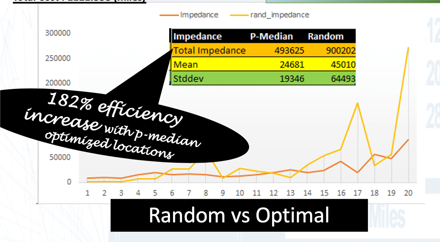
If infections are due to exposure and exposure is a function of distance then infections can be reduced by optimizing travel behavior of infection agents (e.g. doctors, nurses, patients, germs) inside a hospital. We use the Sidney & Lois Eskenazi Hospital at Indiana University Purdue University Indianapolis to demonstrate an ~180 percent increase in ‘time to washing’ efficiency by using best optimal locations for hand washing. We simulated all probable pathways within the hospital architecture (all rooms, hallways, restrooms etc.) using Simulation Science (Polyak averaging), Computer Aided Design (CAD) and Geographic Information Science (GISc) to determine a globally optimal set of locations of disinfection stations (wash place, restrooms, detox stations etc.). We minimize distance to disinfection stations using Network Science, human behavior, Operations Research (p-medians), CAD & GISc. Preliminary results show large variations in distance to infection when sub-optimal locations for disinfection are used. Combining Network Science with Operations Research optimization approach we find best locations for disinfection. Presently, we apply completely chaotic movement behavior (completely deterministic billion plus routes) and robust stochastic optimization techniques to establish empirical proof and theoretical insights. Finally, we would like to show the ’emergent’ or tipping point behavior of COVID19 infections. This would entail obtaining a compendium of hospital floor plans (across all USA) to support the collection of critical ephemeral data and conduct research on an accelerated basis to fight COVID19. Researching confined geometrical and topological spaces will help us understand infection mechanics and would contribute directly to geographic and spatial theory, spatial science, location science and infection epidemiology. In addition, we will investigate the ’emergent’ properties (related to the Reproductive Number R0) in this confined spatial context. We would like to investigate the especially important ‘backward bifurcation and hysteresis’ principle of spatial models as it pertains to p-median optimization that contributes to infection control.
Sidney & Lois Eskenazi Hospital Floor Plan Architecture
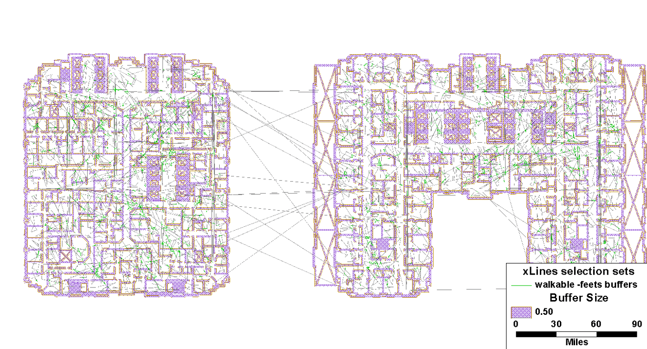

Simulation details of all possible trips inside a section of Hospital floor

OPTIMALLY LOCATED STATIONS
- There is a 182 percent increase in efficiency (against legacy/random/unoptimized detox stations)
- i.e. a significant reduction between wash times
- If applied, there can be a significant reduction in Hospital Acquired infections related deaths
Subsequently, we would like to answer questions from real hospital data that we will collect, as follows:
(Based on hospital floor architecture, we have agents flowing through the network with some latent risk (asymptomatic) and some known risk (nodes w/ patients) and then you have nodes that reduce risk of agents flowing through (washing station). So then the network science questions are …)
- How do you rewire the network (architectural design) to reduce the spread of Covid19?
- How do you optimally place reduction nodes (washing stations) to reduce spread of Covid19?
- Where do you place known risk in the network (patients with Covid19) to minimize risk?
- How do you change behavior or the agents to reduce risk?
In addition, this optimization approach can be adopted to any floor plans like fire stations, office buildings, public places etc. with appropriate parameterization of infection propensities in the network nodes and weighted link nodes. We can join the micro-spatial CAD environment with the meso- & macro- spatial GISc environments to create seamless integration for a comprehensive infection control system for health inside and outside the hospital.”
[White Paper] Hospital Architecture and Preventing Infections: A Network Approach
[The NSF rapid can be a good fit for my NetSci 2018 Paris conference poster Hospital Architecture and Infection Modeling: A Network Approach see https://iu.box.com/s/4c38d79abqhyg9eeucxrc66gdrzhowrh]
- Abstract: If infections are due to exposure and exposure is a function of distance then infections can be reduced (preventative therapy) by optimizing travel behavior of infection agents (e.g. doctors, nurses, patients) inside the hospital. We simulate all probable pathways within the hospital architecture to determine a globally optimal set of locations of disinfection stations (wash place, restrooms, detox stations etc.) that minimizes infections using network/graph theory and GISc. Results show large variations in distance to infection when sub-optimal locations for disinfection are located. Using a graph theoretic integer programming optimization method we find optimal sets locations for disinfection. Presently, we apply completely chaotic movement behavior (completely deterministic) and use robust stochastic optimization techniques to establish further empirical proof.
- Keywords: network science, infection, agent based simulation, operations research, GISc, applied graph theory, hospital architecture.
Covid19 is a specific ‘leaf’ from the SARS-coV-2 ‘branch’ of the Coronavirus ‘tree’.
Nosocomial infections, like MRSA and possibly Covid19 (we don’t know the re-infection rates), are a result of treatment in a hospital, but secondary to the patient’s original condition.
- Before the Covid19 pandemic, the US CDC estimates that the total direct costs of such infections are above $17bn.
- Restating Kho (2008): virus innovate and cooperate and evolve and adapt to resist drugs and can transfer genetic traits between strains …
- For the first time, we apply network science, operations research, stochastic simulations of human behavior and Geographic Information Science to clearly demonstrate flawed hospital processes, including inappropriate sanitizer placements and poor hand washing by providers.
- Collecting bedside vital signs using the latest streamlined and automated processes is potentially increasing interpatient spread of infections.
- It is more important now than ever to provide access to sanitizers/restrooms/detox-units across hospital architecture in an optimal fashion.
- Using networks science, optimal sanitation units can potentially reduce MRSA infections. However, optimal locations can only be empirically derived using very large simulations and optimization algorithms as shown below.
Background
Methicillin-resistant Staphylococcus aureus (MRSA) is a bacterium responsible for difficult-to-treat infections in humans. It may also be referred to as multidrug-resistant Staphylococcus aureus or oxacillin-resistant Staphylococcus aureus (ORSA). MRSA is by definition a strain of Staphylococcus aureus that is resistant to a large group of antibiotics called the beta-lactams, which include the penicillins and the cephalosporins. MRSA/Methicillin Resistant Staphylococcus aureus was discovered in 1961 in the United Kingdom. It made its first major appearance in the United States in 1981 among intravenous drug users. MRSA is often referred to in the press as a “superbug“.

- Nosocomial infections are infections which are a result of treatment in a hospital or a healthcare service unit, but secondary to the patient’s original condition. Infections are considered nosocomial if they first appear 48 hours or more after hospital admission or within 30 days after discharge.Nosocomial comes from the Greek word nosokomeion (νοσοκομείον) meaning hospital (nosos = disease, komeo = to take care of). This type of infection is also known as a hospital-acquired infection (or more generically healthcare-associated infection).
- The Centers for Disease Control and Prevention (CDC) estimates that each year in the United States there are about 1.7 million nosocomial infections in hospitals and 99,000 associated deaths. The estimated incidence is 4.5 nosocomial infections per 100 admissions, with direct costs (at 2004 prices) ranging from $10,500 (£5300, €8000 at 2006 rates) per case (for bloodstream, urinary tract, or respiratory infections in immunocompetent patients) to $111,000 (£57,000, €85,000) per case for antibiotic resistant infections in the bloodstream in patients with transplants. With these numbers, conservative estimates of the total direct costs of nosocomial infections are above $17bn. The reduction of such infections forms an important component of efforts to improve healthcare safety (BMJ 2007).
 IEEE ENGINEERING IN MEDICINE AND BIOLOGY MAGAZINE 0739-5175/08/ ©2008IEEE NOVEMBER/DECEMBER 2008
- Not only that, Kho (2008) states: “Bacteria innovate and cooperate. They evolve and adapt to resist antibiotics and can transfer genetic traits between strains.”

Similarly, Covid19 is highly infectious and require similar sanitation.
Hospital Floor Plan Architecture
Simulation details of all possible trips inside a section of Hospital floor
OPTIMALLY LOCATED STATIONS
- There is a 182 percent increase in efficiency (against legacy/random/unoptimized detox stations)
- i.e. a significant reduction between wash times
- If applied, there can be a significant reduction in Hospital Acquired infections related deaths
APPENDIX
First, [A] we clarify with an Example. Second, [B] we Formalize and Compute the optimal solution.
[A] Example: Suppose there were five detox stations (hand-sanitizing stations, bathrooms etc.) in a hospital floor. Are they optimally location to reduce infections since distance to cleaning facility increases infections proportionately. We want to ‘optimally’ locate these facilities by minimizing the cost of walking to those stations for all travelers on all trips. Costs can be represented in terms of distance or travel times, representing trip impedance, and we can define five optimal “p-median” locations which simultaneously minimizes trip impedance for all locations assuming that every person on the hospital floor wishes to go to their nearest location – the “median” location – minimizing, in principle, the total cost of walking for all points of the floor. Now suppose that there are ‘n’ people walking from some location to these five outlets. The total distance traveled by each person to their nearest station can be measured using shortest paths to the nearest of the five median-based locations.
Not all trips are close to these stations. Trips away from these stations will face more distance and hence they are less accessible.
[B] Formalize and Compute optimal solution: Strategically placing five outlets in order to minimize the total distance traveled by all ‘n’ individuals is a challenging task. Randomly selected the five stations will not be optimal. However, methodically choosing all sets of five locations out of a typical floor with 100s of thousands of potential sites (of stations) provides a combinatorial problem that requires more than polynomial computation time O(Nk). This location problem is common in determining geographic locations of outlets and other businesses or services that wish to optimize locations relative travel patterns in urban settings and can be solved using a group of mathematical models called the p-median problem and is typically formulated as an Integer Program (IP) (ReVelle and Eiselt 2005)[1].
The least cost trip can be identified as that route which minimizes distances to the 5-locations. But we can also define a second least cost route, a third least cost route, and so on (i.e., called k-routes, where k=1 means the least cost one; e.g when we use Google routes they provide k=3 or 3 best routes ranked). Therefore, for any ‘p’-median location of outlets, ‘n’ people can take k-routes. In the mathematical optimization context, this translates into a parsimonious representation by using graph theory where: p-median (nodes), n people (nodes) and ‘k’ routes (links) form a network that can mathematically be investigated for optimal location of p-medians when k=1 (the shortest route chosen). Direct estimation of all possible k-routes would be an ideal way to simulate human behavior since people may not take or know the optimal route. In addition, solving this problem would take exponentially more computational time as number of people (n) increase (an NP-hard problem, (Reese, n.d.); (Schrijver 1986)). We can, however, simulate a sample of k-routes using computational methods and convert a well-defined deterministic but computationally hard problem into a probabilistic but computationally easy problem.
REFERENCES
Albert, Réka, Hawoong Jeong, and Albert-László Barabási. 2000. “Error and Attack Tolerance of Complex Networks.” Nature 406 (6794): 378–82. https://doi.org/10.1038/35019019.
Hakimi, S. L. 1965. “Optimum Distribution of Switching Centers in a Communication Network and Some Related Graph Theoretic Problems.” Operations Research 13 (3): 462–75.
ReVelle, C. S., and H. A. Eiselt. 2005. “Location Analysis: A Synthesis and Survey.” European Journal of Operational Research 165 (1): 1–19. https://doi.org/10.1016/j.ejor.2003.11.032.
Schrijver, Alexander. 1986. Theory of Linear and Integer Programming. USA: John Wiley & Sons, Inc.
Winston, Wayne, and Jeffrey Goldberg. 2004. Operations Research: Applications and Algorithms.
