The idea
“1 Trillion Drone Trips!” I presented this idea at the ‘Internet of Things Symposium’ held at Indiana University in April 2019. Imagine, in 2050, a grandma wants an elephant shaped refrigerator and her granddaughter taps on her haptic “screen” ordering “one-tap” from Walmart a modular refrigerator to be 3D printed at their massive 3D printer shop 2 miles away, shipped 2 pounds at a time by a fleet of 150 electric ultralight drones! And, assembled by the $5000 home robot, relieving grandma of all the trouble of purchasing, assembling and siting early 21st century 3D objects in her private environment.
“Electrification of aircraft, in general, is expected to fundamentally change the aerospace industry in the near future,” Furbush said.
Americans took ~ 411 billion daily vehicle trips in 2019 or about 1,500 trips per person. With the above grandma example, capitalist societies will hyper charge delivery, far beyond the half-trillion trips, similar to what we saw with the communications explosion triggered by the internet (phone calls to video chat sharing).
I am proposing a new idea to make drones follow a 3D ‘operating system’ that replicates our already existing terrestrial roadway system … to be replicated in the sky.
Electric vehicles in the air!
There is a composite image of Heathrow airport flights (Getty Images)
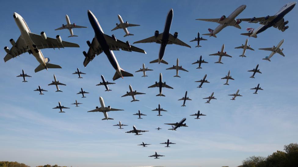
With drones this kind of imagery might turn into a nightmarish reality unless we develop a drone operating system that will be allow the smooth operation of a trillion drones or more.
What will it take to achieve this idea, and why now?
There are ~50 million road segments in the US and it has all the trapping of complex traffic rules. Automated vehicles are predicted to use our existing roads. However, due to automation they need no traffic lights or other traffic furniture (everything is software based with minimum on-board hardware that, with predictive routing software, can be controlled from a centralized computer system). To achieve such a system on the ground Google and other companies promised fully automated cars but now there is a realization that automation requires more intelligent (AI) software due to random elements (bicyclists, pedestrians, snow etc). With present day software we can fly drones at 300 feet above the ground where we will not encounter random elements (except for birds and weather elements, but we have a solution to that). Drones are inexpensive to build and fly (they do not require safety features like fully automated cars since this idea entails drones without passengers).
The FAA regulates airspace and allows drones 200-400 feet above the ground. No flying above buildings or humans, the public space where humans are not static are roads and we do not built on the airspace above roads (except for tunnels).
I developed, using the latest traffic simulation geographic information software, a traffic-signal-less operating system for terrestrial vehicles and projected them into space 300 feet above ground. 200 to 400 feet is the FAA restriction for drone space so a ‘sewer pipeline like’ VIRTUAL aerial highway will be used and sold to companies (similar to how the FCC -Federal Communications Commission ‘sells’ airwaves). This will eliminate the chaos of insect-like swarms of drones affecting quality of life by restricting airspace based on a regulatory framework. In addition, centrally planned trips would eliminate ‘unqualified’ and rogue drones to ever violate this delicate and extraordinary space. We may call this innovation what’s essentially a 3D electric transport architecture and software operating system into one. Essentially, it entails an assembly line type foolproof system where drones are to fly in a designated space with enough stochasticity built in to mitigate accidents and errors.
Ground transportation requires human (drivers), machines (cars, bikes), traffic furniture (lights, stop signs), centralized software (Google type routing, dynamic traffic signalling) and traffic safety (cops, legislation for injuries, fines, insurance). Drones require just centralized software and traffic safety in case of rare accidents (a fleet of highly monitored and automated rescue drone cops will ‘rescue’ distressed drones and escort them to safety pods situated at intervals designed to fail-safe the system. So, no horror scenarios like falling debris!
It takes around 2 hours, using terrestrial transportation GIS simulation software Transmodeler™ (the most advanced in the market), to simulate say, downtown San Francisco. See my example of “A Blueprint for a Drone Skyway” video here:
The Federal Communications Commission (FCC) conducts auctions on electromagnetic spectrum and since 1994 has auctioned off billions of dollars in spectrum sales. “…The auction that began on March 29, 2016, ended on March 30, 2017. The total net winning bids of $19.3 billion …”
Instead of everyone using drones by themselves, an FCC type ‘3D electric airspace spectrum’ at 300 feet above ground level will be auctioned off to companies and the money will be used to monitor and control drone space like the FCC and 3D support from FAA and local public safety to ensure total safety.
Airspace Classification
According to FAA “The two categories of airspace are: regulatory and nonregulatory. Within these two categories, there are four types: controlled, uncontrolled, special use, and other airspace. The categories and types of airspace are dictated by the complexity or density of aircraft movements, nature of the operations conducted within the airspace, the level of safety required, and national and public interest.”
 (image credit FAA)
What does GIS have got to do with all this?
In a recent paper by Dr Howard Slavin and associates at Caliper Corporation ( the most advanced traffic simulation software producers in the world), it is stated that Geographic Information Systems software is best suited for simulation of traffic:
” … Congestion patterns are estimated at the lane level with explicit modeling of
complex signal timing algorithms and their impacts on queues and spillbacks. A Geographic Information System (GIS) ensures the most accurate network representation [*my emphasis].The flexible representation of travel demand at the resolution of individual vehicles facilitates the capturing of sufficient vehicle and driver classes, vehicle performance and driving behavior distributions, inter-vehicle interactions, and temporally fine trajectories. …”
Stochastic Approximation and Simulation
Stochastic approximation is needed when — for instance in engineering, many optimization problems are often of the type when you do not have a mathematical model of the system (which can be too complex) but some parameters can be adjusted using simulation testing. Poylak approximation is used (Transmodeler software from Caliper corporation) to accurately predict traffic (speed, clustering etc) and allow parameters like driver behavior and signal systems to be manipulated.
With such complex terrestrial simulation being adopted in the real world, simulating drones will be quite ordinary. Transmodeler allows for level 5 automation (car that are driverless) to zero automation (like bikes and pedestrians and some automobiles). Since drones will be driverless, they will follow level 5 automation only. This will ensure simpler traffic situations even with 1 trillion trips or more. The 50 million road segments (that covers almost all houses and buildings) will be burdened with drone traffic (so road traffic pattern may be mimicked). However, instead of ground level, it will be up in the sky at 300 ft (30 story rooftop height). Since drones will be lightweight and compact, they will hardly be visible to the naked eye.
Package deliveries
Drone package deliveries will follow the Flirtey model (they use a “rope” type tether that lowers the delivery box and the drone does not land). We will ensure that drones take off and land at their point of origin and deliver midway using ropes. This avoids drones to land and create chaos. Accidents will be avoided with on the fly drone cops escorting malfunctioning drones away for safe disposal/repair. Even debris can be caught by cop drone nets and quickly brought to safety.
Minimum Disruption
Finally, in the article The ethics of emerging technologies, Fred Fonseca of Pennsylvania State University is quoted about data and ethics:
“Scientists use the really-existing data to feel along and interact with the really-existing world, engaging data not as a representation, but as an instrument to help facilitate their empirical thinking,” he explained. “Like the cane, data is used as an extension of their senses, with their understanding of the world being dynamically coupled with the massive streams of data found in data-driven science.”
With the potential for phenomenal electric transport, our challenges to data ethics will increase exponentially. This white paper outlines a way to adopt electric transport with the least disruption to society.